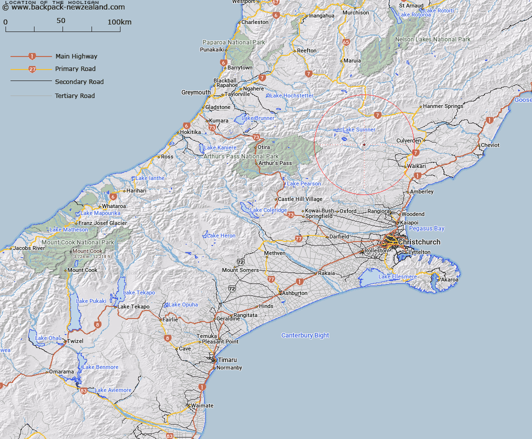
Map showing location of The Hooligan


LINZ description: Range of hills from Mount Mizar to Hooligan Peak. Blocks X and XI Mytholm Survey District.
Latitude: -42.8063
Longitude: 172.397396
Northing: 5260518.8
Easting: 1550728.7
Land District: Canterbury
Feat Type: Range


Scroll down to see a more detailed road map and below that a topographical map showing the location of The Hooligan. The road map has been supplied by openstreetmap and the topographical map of The Hooligan has been supplied by Land Information New Zealand (LINZ).

Yes you can use the top static map for you school/university project or personal website with a link back. Contact me for any commercial use.

The Hooligan Map New Zealand


New Zealand places in our database
[ A ] [ B ] [ C ] [ D ] [ E ] [ F ] [ G ] [ H ] [ I ] [ J ] [ K ] [ L ] [ M ] [ N ] [ O ] [ P ] [ Q ] [ R ] [ S ] [ T ] [ U ] [ V ] [ W ] [ X ] [ Y ] [ Z ]


Closest 20 Ranges to The Hooligan

The Braes ( 7.21km )   Cavendish Hills ( 10.47km )   The Sisters ( 10.78km )   Oronoko Range ( 11.79km )   The Brothers ( 15.01km )   Glynn Wye Range ( 15.99km )   Organ Range ( 16.24km )   The Little Island Hills ( 17.43km )   The Big Island Hills ( 19.07km )   Tekoa Range ( 24.63km )   Studleigh Range ( 24.7km )   Puketeraki Range ( 24.91km )   Doctors Hills ( 27.05km )   Pancake Range ( 29.26km )   Crawford Range ( 29.54km )   Culverden Range ( 30.37km )   Doubtful Range ( 30.54km )   The Nelson Tops ( 30.7km )   The Candlesticks ( 30.82km )   Okuku Range ( 30.85km )   Poplars Range ( 31.28km )   Dampier Range ( 35.87km )   Sylvia Tops ( 36.68km )   Kingsdown Hills ( 37.86km )   Poulter Range ( 40.84km )   Libretto Range ( 41.34km )   Snow Cup Range ( 45.59km )   Opera Range ( 48.94km )   Lowry Peaks Range ( 50.2km )   Savannah Range ( 50.88km )   Hanmer Range ( 52.05km )   Freyberg Range ( 52.21km )   Spenser Range ( 55.67km )   St James Range ( 57.03km )   Polar Range ( 60.9km )   Aicken Range ( 60.94km )   Kaimata Range ( 62.59km )   The Humps ( 65.47km )   Alexander Range ( 66.39km )   Torlesse Range ( 66.65km )