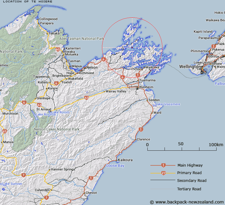
Map showing location of Te Hoiere


LINZ description: Pelorus Sound (Te Hoiere, 1930 Hon p. 34) Island official under both English and Maori names. Feature shown on: NZMS260 O26 P25 Pt P26
Latitude: -41.023996
Longitude: 173.88734
Northing: 5458200
Easting: 1674600
Land District: Marlborough
Feat Type: Island


Scroll down to see a more detailed road map and below that a topographical map showing the location of Te Hoiere. The road map has been supplied by openstreetmap and the topographical map of Te Hoiere has been supplied by Land Information New Zealand (LINZ).

Yes you can use the top static map for you school/university project or personal website with a link back. Contact me for any commercial use.

Te Hoiere Map New Zealand


New Zealand places in our database
[ A ] [ B ] [ C ] [ D ] [ E ] [ F ] [ G ] [ H ] [ I ] [ J ] [ K ] [ L ] [ M ] [ N ] [ O ] [ P ] [ Q ] [ R ] [ S ] [ T ] [ U ] [ V ] [ W ] [ X ] [ Y ] [ Z ]


Closest 20 Islands to Te Hoiere

Clara Island ( 2.77km )   Dart Rock ( 6.3km )   Karaka (Hamilton Island) ( 6.68km )   Tawhitinui Island ( 7.78km )   White Horse Rock ( 8.4km )   Tarakaip? Island ( 8.93km )   Ouokaha Island ( 12.21km )   Le Brun Peninsula ( 12.42km )   Le Brun Island ( 12.42km )   Hautai Island ( 12.54km )   Bird Island ( 12.82km )   Sugar Loaf ( 13.23km )   Wharenoa (Cemetery Island) ( 13.65km )   Anatakupu Island ( 14.26km )   Rabbit Island ( 14.26km )   Cone Island ( 14.48km )   Stewart Island (Tekuru Kuru) ( 15.13km )   Oke Rock ( 16.02km )   Te Horo Island ( 16.77km )   H?puka Island ( 17.14km )   Forsyth Island (Te Paruparu) ( 17.5km )   Taungahaika Islands ( 17.76km )   Taunahaika Islands ( 17.76km )   Shag Rock ( 17.87km )   Ninepin Rock ( 18.56km )   Rahuinui ( 18.86km )   Otuhaereroa Island ( 19.21km )   Moukirikiri Island ( 19.9km )   Clark Island ( 19.95km )   Penguin Island ( 20.34km )   Motuanauru Island ( 20.77km )   Nukuwaiata Island ( 20.89km )   The Haystack (Moturaka) ( 21.52km )   Rangitoto ke te Tonga (D'Urville Island) ( 22.14km )   Rangitoto ki te Tonga/D'Urville Island ( 22.14km )   Rangitoto ki te Tonga (D'Urville Island) ( 22.14km )   Trio Islands (Kuru Pongi) ( 22.19km )   Titi Island ( 22.63km )   Chetwode Islands ( 22.68km )   Tu Araiawa Island (Fin Island) ( 23.63km )