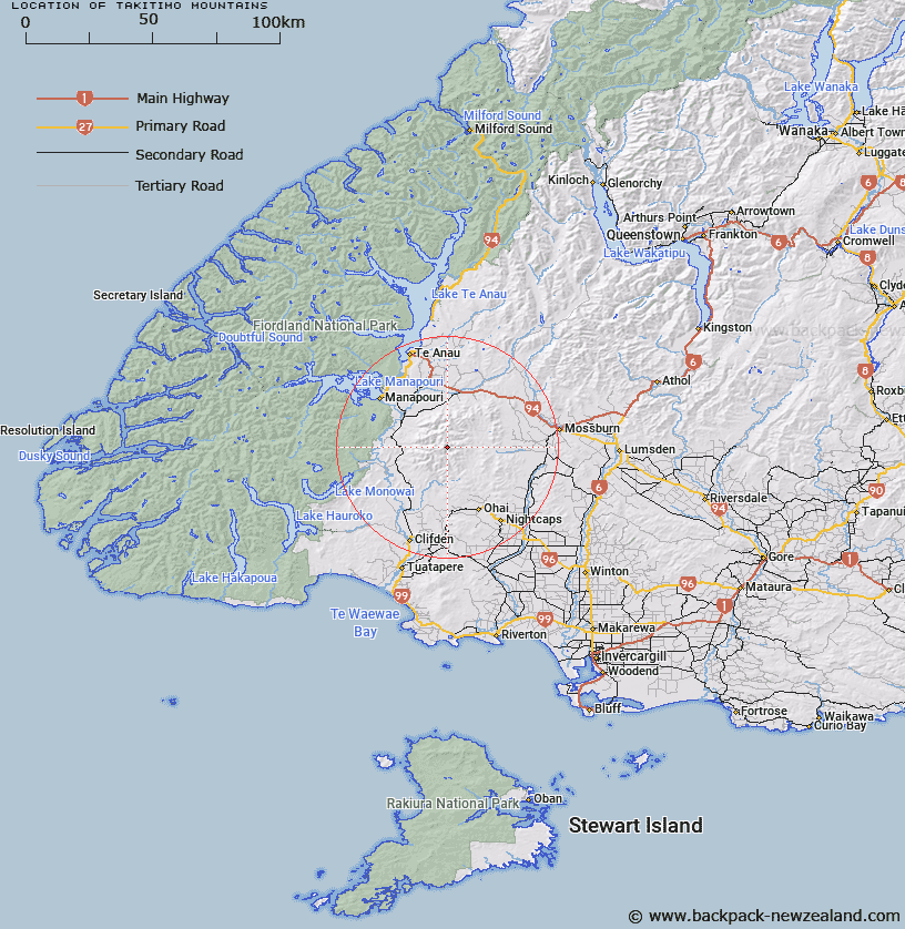
Map showing location of Takitimo Mountains


LINZ description: Mountain chain stretching from Brown Peak in the North, to Gibraltar Hill in the south, 25km Southeast of Lake Manapouri. Takitimu Survey District. Feature shown on Infomap 346-02 Te Wai Pounamu Edition 1 1995
Latitude: -45.727782
Longitude: 167.845739
Northing: 4923263.4
Easting: 1198954.5
Land District: Southland
Feat Type: Range


Scroll down to see a more detailed road map and below that a topographical map showing the location of Takitimo Mountains. The road map has been supplied by openstreetmap and the topographical map of Takitimo Mountains has been supplied by Land Information New Zealand (LINZ).

Yes you can use the top static map for you school/university project or personal website with a link back. Contact me for any commercial use.

Takitimo Mountains Map New Zealand


New Zealand places in our database
[ A ] [ B ] [ C ] [ D ] [ E ] [ F ] [ G ] [ H ] [ I ] [ J ] [ K ] [ L ] [ M ] [ N ] [ O ] [ P ] [ Q ] [ R ] [ S ] [ T ] [ U ] [ V ] [ W ] [ X ] [ Y ] [ Z ]


Closest 20 Ranges to Takitimo Mountains

Takitimu Mountains ( 0km )   Takitimo Mountains ( 0km )   Chimney Peaks ( 4.46km )   Family Peaks ( 5.55km )   The Haycocks ( 28.87km )   Taringatura Hills ( 33.19km )   North Range ( 35.97km )   Hunter Mountains ( 36.77km )   Camel Backs ( 39.87km )   Jackson Peaks ( 41.36km )   Cathedral Peaks ( 43.07km )   Turret Range ( 44.98km )   Kaherekoau Mountains ( 44.99km )   Townley Mountains ( 47.5km )   Lintley Range ( 47.51km )   Wall Mountains ( 49.41km )   Helen Peaks ( 50.7km )   Merrie Range ( 53.07km )   Kepler Mountains ( 53.33km )   Longwood Range ( 55.3km )   Matterhorn Mountains ( 55.97km )   Pleasant Range ( 56.22km )   Hokonui Hills ( 56.5km )   Kilcoy Mountains ( 56.95km )   Dunton Range ( 58.27km )   Mataura Range ( 59.62km )   Princess Mountains ( 60.35km )   Heath Mountains ( 60.78km )   Dana Peaks ( 60.78km )   Dingwall Mountains ( 61.55km )   Beatrice Peaks ( 62.19km )   Braan Mountains ( 63.45km )   Slate Range ( 65.28km )   Eyre Mountains ( 65.57km )   Murchison Mountains ( 66.96km )   Turret Peaks ( 67.72km )   Countess Range ( 70.16km )   Museum Range ( 70.6km )   Behind Peaks ( 71.84km )   Howitt Peaks ( 72.7km )