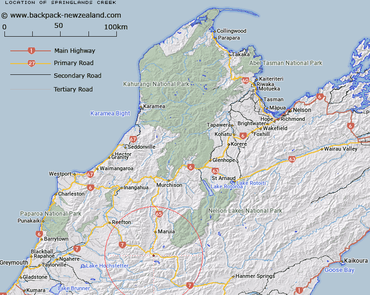
Map showing location of Springlands Creek


LINZ description: Right bank tributary of Black Stream rising 1km North-east of Trig. C (Geodetic Code A83N)], flowing northward, and joining Black Stream at Springs Junction locality. Block III, Lewis Survey District.
Latitude: -42.364197
Longitude: 172.206486
Northing: 5309481.2
Easting: 1534658.9
Land District: Nelson
Feat Type: Stream


Scroll down to see a more detailed road map and below that a topographical map showing the location of Springlands Creek. The road map has been supplied by openstreetmap and the topographical map of Springlands Creek has been supplied by Land Information New Zealand (LINZ).

Yes you can use the top static map for you school/university project or personal website with a link back. Contact me for any commercial use.

Springlands Creek Map New Zealand


New Zealand places in our database
[ A ] [ B ] [ C ] [ D ] [ E ] [ F ] [ G ] [ H ] [ I ] [ J ] [ K ] [ L ] [ M ] [ N ] [ O ] [ P ] [ Q ] [ R ] [ S ] [ T ] [ U ] [ V ] [ W ] [ X ] [ Y ] [ Z ]


Closest 20 Streams to Springlands Creek

Springlands Creek ( 0km )   Mill Stream ( 0km )   Black Stream ( 2.79km )   Five Mile Creek ( 3.39km )   Four Mile Creek ( 3.52km )   Jackson Creek ( 3.52km )   Jacksons Creek ( 3.52km )   Alfred River ( 4.05km )   Rahu River ( 4.94km )   Crooked Mary Creek ( 5.03km )   Newcombe Creek ( 6.24km )   Cliff Creek ( 6.24km )   Pell Stream ( 6.31km )   Rough Creek ( 6.62km )   Three Mile Creek ( 6.62km )   Blue Grey River ( 7.17km )   Rocky Creek ( 7.2km )   Gilchrist Creek ( 7.45km )   Reid Stream ( 8.09km )   Lock Creek ( 8.13km )   Frazer Stream ( 8.21km )   Brown Grey River ( 8.79km )   Rahu River Right Branch ( 8.84km )   One Mile Creek ( 8.9km )   Rahu River Left Branch ( 9.78km )   Waterfall Creek ( 10.52km )   Jack Creek ( 11km )   Slatey Creek ( 12.23km )   May Creek ( 12.4km )   Nina River ( 12.68km )   Duchess Stream ( 12.96km )   Lake Stream ( 13.09km )   Twenty Mile Creek ( 13.77km )   Tindale Creek ( 14.07km )   Tindall Creek ( 14.07km )   Left Branch Maruia River ( 14.21km )   Hawker Creek ( 14.33km )   Lawson Creek ( 14.46km )   Lucretia Stream ( 14.97km )   Blind Stream ( 14.98km )