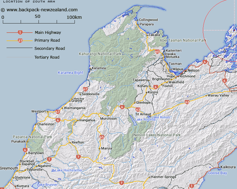
Map showing location of South Arm


LINZ description: Feature shown on: NZMS260 O26 P25 Pt P26 Edition 1 1980; NZTopo50-BN28 737837
Latitude: -40.794391
Longitude: 173.873608
Northing: 5483700
Easting: 1673700
Land District: Nelson
Feat Type: Bay


Scroll down to see a more detailed road map and below that a topographical map showing the location of South Arm. The road map has been supplied by openstreetmap and the topographical map of South Arm has been supplied by Land Information New Zealand (LINZ).

Yes you can use the top static map for you school/university project or personal website with a link back. Contact me for any commercial use.

South Arm Map New Zealand


New Zealand places in our database
[ A ] [ B ] [ C ] [ D ] [ E ] [ F ] [ G ] [ H ] [ I ] [ J ] [ K ] [ L ] [ M ] [ N ] [ O ] [ P ] [ Q ] [ R ] [ S ] [ T ] [ U ] [ V ] [ W ] [ X ] [ Y ] [ Z ]


Closest 20 Bays to South Arm

South Arm ( 0km )   Rene Cove ( 0.69km )   Smokehouse Bay ( 1.03km )   Allman Bay ( 1.18km )   Wells Bay ( 2.56km )   Moki Bay ( 2.56km )   Wells Arm ( 2.85km )   Waiua Bay ( 3.31km )   East Arm ( 3.72km )   Port Hardy ( 3.81km )   Deserter Bay ( 4.47km )   Punaatawheke Bay ( 4.57km )   Punaatawake Bay ( 4.57km )   Ot? Bay ( 4.85km )   Camp Bay ( 5.28km )   Massacre Bay ( 5.48km )   Whare?tea Bay ( 5.75km )   Whareata Bay ( 5.75km )   Black Reef Bay ( 5.92km )   Pireka (Low Neck Bay) ( 6.19km )   Low Neck Bay ( 6.19km )   Low Neck Bay ( 6.21km )   Waitai Bay ( 6.25km )   Lookout Bay ( 6.45km )   Skull Bay ( 6.64km )   Mill Arm ( 6.72km )   Swamp Bay ( 7.58km )   Mokau Bay ( 7.63km )   Greville Harbour / Wharariki ( 7.77km )   Greville Harbour ( 7.77km )   Paddy Bay ( 7.8km )   Whare-ririki Bay ( 8.02km )   Whare-ririki Bay ( 8.08km )   Wharairiki Bay ( 8.08km )   Catherine Cove ( 8.35km )   Punt Arm ( 8.61km )   Garden Bay ( 8.62km )   Bullock Bay ( 8.64km )   Cherry Tree Bay ( 8.67km )   Smylies Arm ( 8.79km )