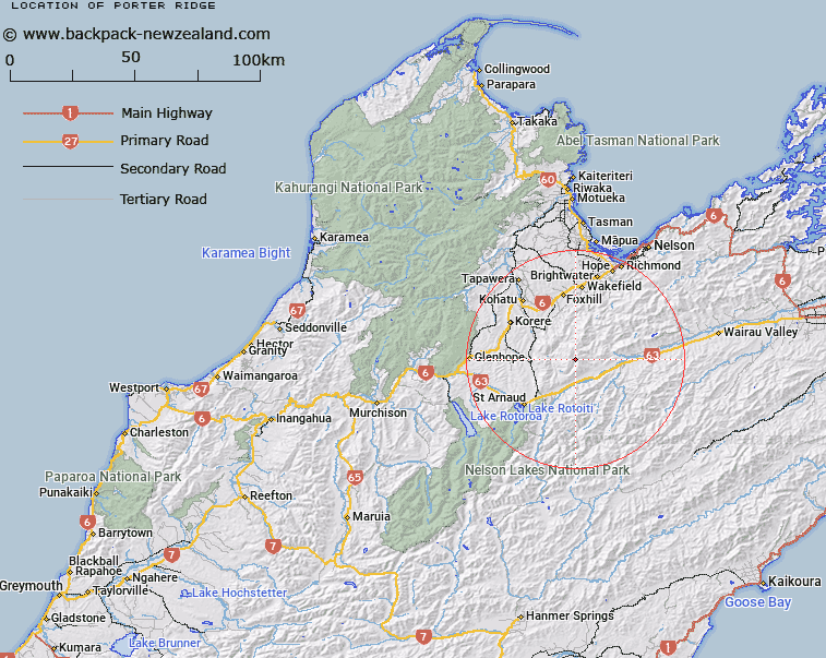
Map showing location of Porter Ridge


LINZ description: Mountain ridge extending south westerly from a point Topo50 BR25 034933, to, and lying to west of, the Right Branch, Motueka River. Block XIV Gordon and Blocks IV and VIII Motupiko Survey District.
Latitude: -41.652148
Longitude: 173.024746
Northing: 5388843.9
Easting: 1602060.6
Land District: Nelson
Feat Type: Ridge


Scroll down to see a more detailed road map and below that a topographical map showing the location of Porter Ridge. The road map has been supplied by openstreetmap and the topographical map of Porter Ridge has been supplied by Land Information New Zealand (LINZ).

Yes you can use the top static map for you school/university project or personal website with a link back. Contact me for any commercial use.

Porter Ridge Map New Zealand


New Zealand places in our database
[ A ] [ B ] [ C ] [ D ] [ E ] [ F ] [ G ] [ H ] [ I ] [ J ] [ K ] [ L ] [ M ] [ N ] [ O ] [ P ] [ Q ] [ R ] [ S ] [ T ] [ U ] [ V ] [ W ] [ X ] [ Y ] [ Z ]


Closest 20 Ridges to Porter Ridge

Red Hills Ridge ( 3.2km )   Gibbs Spur ( 12.96km )   Prospect Ridge ( 28.45km )   Christie Ridge ( 29.72km )   Robert Ridge ( 31.37km )   Fork Spur ( 33.9km )   Angelus Ridge ( 36.44km )   Canterbury Spur ( 36.87km )   Mangerton Ridge ( 37.39km )   Saw Spur ( 39.92km )   Fifteen Mile Spur ( 40.37km )   Jones Ridge ( 41.22km )   Cummins Spur ( 43.86km )   Wells Ridge ( 44.08km )   Bullock Spur ( 44.64km )   Stafford Ridge ( 49.36km )   Rocky Gill Spur ( 49.84km )   Bald Knob Ridge ( 50.21km )   Boars Back Spur ( 51.59km )   Cowin Spur ( 52.01km )   Paddy Ridge ( 52.75km )   Franklin Ridge ( 52.79km )   Turk Ridge ( 53.26km )   Billys Spur ( 53.3km )   Pearse Ridge ( 53.65km )   Blue Cliffs Ridge ( 54.17km )   Luna Ridge ( 56.22km )   The Fingerpost ( 56.53km )   Balaclava Ridge ( 58.76km )   Newton Ridge ( 59.84km )   Starvation Ridge ( 61.26km )   The Castles ( 61.78km )   Three Sisters ( 61.89km )   Scarecrow Spur ( 62.24km )   Tongue Spur ( 63.17km )   Kendall Ridge ( 63.62km )   Inkerman Ridge ( 63.89km )   The Black Spur ( 64.1km )   Rough Spur ( 64.27km )   Hooper Ridge ( 64.73km )