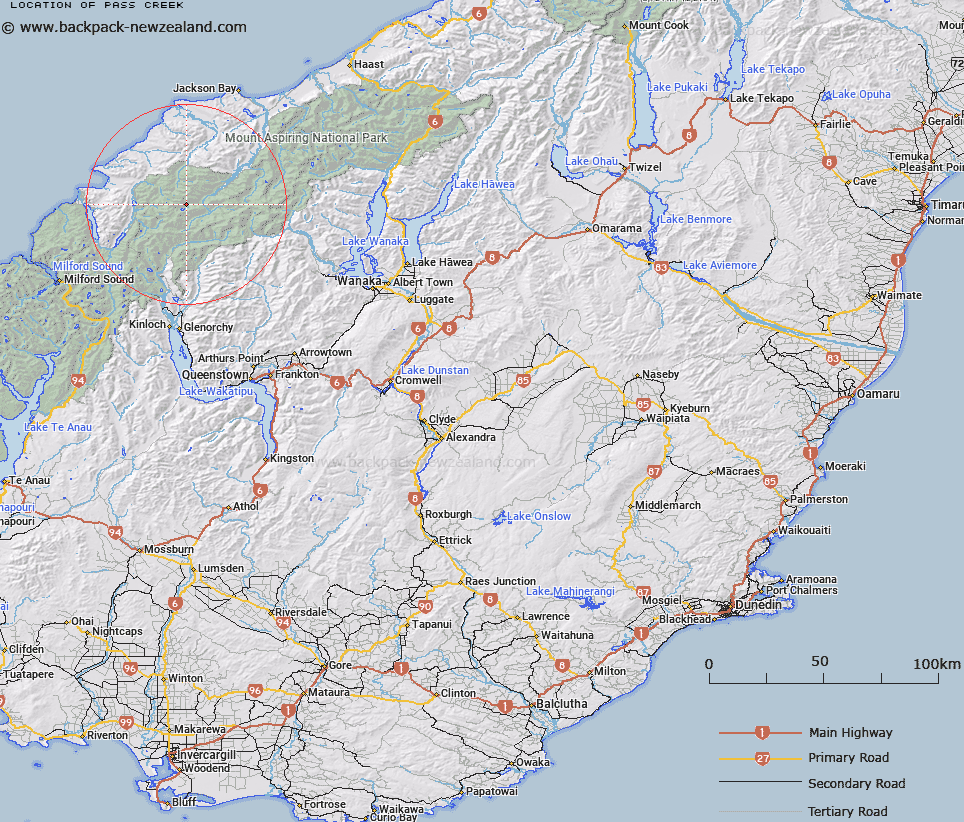
Map showing location of Pass Creek


LINZ description: Flows from the Trinity Ice-field to the Williamson River
Latitude: -44.393425
Longitude: 168.415868
Northing: 5074200
Easting: 1234900
Land District: Otago
Feat Type: Stream


Scroll down to see a more detailed road map and below that a topographical map showing the location of Pass Creek. The road map has been supplied by openstreetmap and the topographical map of Pass Creek has been supplied by Land Information New Zealand (LINZ).

Yes you can use the top static map for you school/university project or personal website with a link back. Contact me for any commercial use.

Pass Creek Map New Zealand


New Zealand places in our database
[ A ] [ B ] [ C ] [ D ] [ E ] [ F ] [ G ] [ H ] [ I ] [ J ] [ K ] [ L ] [ M ] [ N ] [ O ] [ P ] [ Q ] [ R ] [ S ] [ T ] [ U ] [ V ] [ W ] [ X ] [ Y ] [ Z ]


Closest 20 Streams to Pass Creek

Williamson River ( 1.24km )   Tornado Creek ( 1.62km )   Topsey Creek ( 2.06km )   Ridge Creek ( 4.46km )   Retreat Creek ( 5.4km )   Sealy Stream ( 5.81km )   Limbo Stream ( 6.07km )   Trinity Stream ( 6.61km )   Halfway Creek ( 6.68km )   Holland Creek ( 6.79km )   Crescent Creek ( 7.31km )   Malcolm Creek ( 7.74km )   South Snowball Creek ( 7.83km )   Silver Stream ( 7.85km )   Ten Hour Gorge Creek ( 8.25km )   Simonin Stream ( 8.36km )   Joe River ( 8.72km )   Rata Creek ( 8.78km )   Snowball Creek ( 8.86km )   Barrier River North Branch ( 9.13km )   Kea Creek ( 9.2km )   Collins Creek ( 9.3km )   Saddle Stream ( 9.3km )   Barrier River South Branch ( 9.37km )   Steep Creek ( 9.41km )   Southern Cross Creek ( 9.76km )   Stokes Creek ( 9.87km )   Arcade Creek ( 9.9km )   Phantom Creek ( 9.91km )   Victor Creek ( 10.09km )   Peanut Stream ( 10.12km )   Barrington Creek ( 10.17km )   Fez Creek ( 10.53km )   Red Stream ( 10.61km )   Blockade Stream ( 11.46km )   Mercer Stream ( 11.53km )   Yashmak Creek ( 12.18km )   McTavish Creek ( 12.21km )   Peridot Stream ( 12.42km )   Milner Ice Stream ( 12.53km )