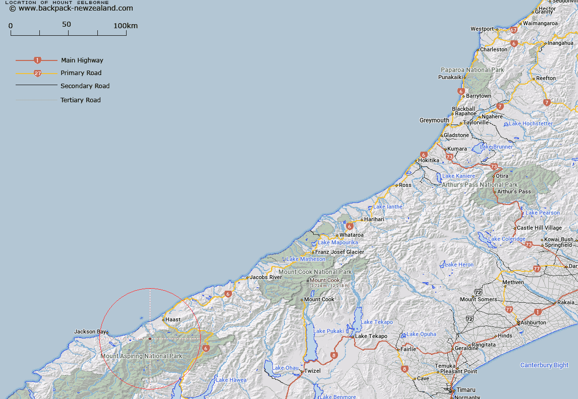
Map showing location of Mount Selborne


LINZ description: Mountain at height 1864m, located approximately 17 km south-west of Haast.
Latitude: -44.018851
Longitude: 168.938699
Northing: 5118009.7
Easting: 1274482.3
Land District: Westland
Feat Type: Hill


Scroll down to see a more detailed road map and below that a topographical map showing the location of Mount Selborne. The road map has been supplied by openstreetmap and the topographical map of Mount Selborne has been supplied by Land Information New Zealand (LINZ).

Yes you can use the top static map for you school/university project or personal website with a link back. Contact me for any commercial use.

Mount Selborne Map New Zealand


New Zealand places in our database
[ A ] [ B ] [ C ] [ D ] [ E ] [ F ] [ G ] [ H ] [ I ] [ J ] [ K ] [ L ] [ M ] [ N ] [ O ] [ P ] [ Q ] [ R ] [ S ] [ T ] [ U ] [ V ] [ W ] [ X ] [ Y ] [ Z ]


Closest 20 Hills to Mount Selborne

The Woolsack ( 2.86km )   The Round Hill ( 3.4km )   Mount Warren ( 5.75km )   Souter Peak ( 6.06km )   Mount Harris ( 8.5km )   Mount Eggeling ( 8.51km )   Gill Hill ( 8.53km )   Mount Watney ( 8.68km )   Mount Ruera ( 9.13km )   The Wart ( 9.3km )   Mount Calliope ( 10.31km )   The Cairn ( 10.37km )   Mount Franklin ( 10.57km )   Nisson Hill ( 10.78km )   Mount Lycia ( 11.03km )   Mount Attica ( 12.33km )   Bain Hill ( 12.34km )   Mount Dispute ( 12.88km )   Mount Marks ( 12.91km )   Mount Mark ( 12.91km )   Mount Browne ( 13.05km )   Howe Knob ( 13.22km )   Brownes Knobs ( 13.42km )   Mount Doris ( 13.66km )   Mount Wzania ( 13.95km )   Trident Peak ( 14.21km )   Mount Dreadful ( 14.33km )   Young Peak ( 14.88km )   Mount McLean ( 15.05km )   Quartz Hill ( 15.08km )   Mount Heveldt ( 15.2km )   Mount Glissa ( 15.33km )   Foggy Top ( 15.45km )   Rough Ridge ( 15.61km )   Mount Clio ( 15.75km )   Mount Nerger ( 15.93km )   Misty Peak ( 15.94km )   Macfarlane Mound ( 16.49km )   Big Bluff ( 16.68km )   Mount Tyndar ( 16.78km )