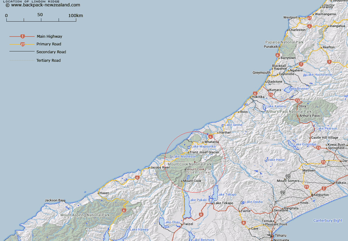
Map showing location of Lindon Ridge


LINZ description: The mountain ridge extending north-westerly from the Minarets on the Main Divide in Westland National Park
Latitude: -43.503763
Longitude: 170.262526
Northing: 5179600
Easting: 1378700
Land District: Westland
Feat Type: Ridge


Scroll down to see a more detailed road map and below that a topographical map showing the location of Lindon Ridge. The road map has been supplied by openstreetmap and the topographical map of Lindon Ridge has been supplied by Land Information New Zealand (LINZ).

Yes you can use the top static map for you school/university project or personal website with a link back. Contact me for any commercial use.

Lindon Ridge Map New Zealand


New Zealand places in our database
[ A ] [ B ] [ C ] [ D ] [ E ] [ F ] [ G ] [ H ] [ I ] [ J ] [ K ] [ L ] [ M ] [ N ] [ O ] [ P ] [ Q ] [ R ] [ S ] [ T ] [ U ] [ V ] [ W ] [ X ] [ Y ] [ Z ]


Closest 20 Ridges to Lindon Ridge

De la Beche Ridge ( 2.93km )   Drummond Ridge ( 4.8km )   Penck Ridge ( 5.31km )   Sollas Ridge ( 5.98km )   Burton Range ( 6.04km )   Burton Ridge ( 6.04km )   Ayres Ridge ( 6.76km )   Hende Ridge ( 6.9km )   Pioneer Ridge ( 7.33km )   Coulter Ridge ( 7.87km )   Huntington Ridge ( 8.26km )   Haast Ridge ( 10.24km )   Syme Ridge ( 10.31km )   Chancellor Ridge ( 11.8km )   Cole Spur ( 12.94km )   Bowie Ridge ( 12.97km )   Zurbriggen Ridge ( 13.01km )   Passchendaele Ridge ( 13.57km )   Paschendale Ridge ( 13.57km )   North East Ridge ( 13.66km )   North Ridge ( 13.94km )   East Ridge ( 14.29km )   Earle Ridge ( 14.86km )   North West Ridge ( 15.6km )   Hillary Ridge ( 15.61km )   South Ridge ( 15.61km )   Gunn Ridge ( 15.73km )   West Ridge ( 16.3km )   Botanical Spur ( 23.24km )   Crumbling Ridge ( 24.42km )   Little Rough ( 28.86km )   Big Rough ( 30.05km )   Razor Back ( 30.98km )   Hoophorn Spur ( 32.05km )   Murphy Spur ( 33.54km )   Little Spur ( 34.07km )   Joseph Ridge ( 34.07km )   Big Spur ( 34.99km )   Devils Backbone ( 36.62km )   Eves Rib ( 39km )