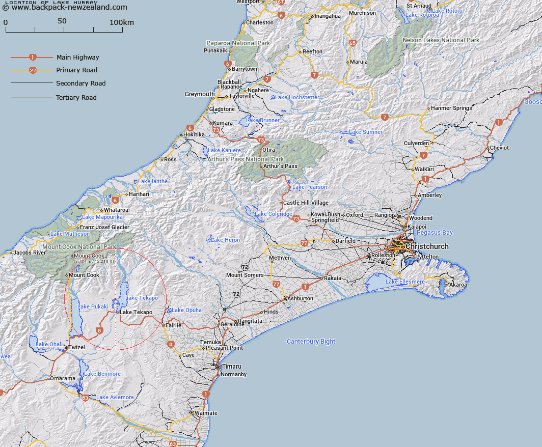
Map showing location of Lake Murray


LINZ description: Small lake adjacent to Glenmore - Godley Peaks Road, 1.4km South-east of Glenmore Homestead. Block V Tekapo Survey District.
Latitude: -43.904136
Longitude: 170.468941
Northing: 5135660.2
Easting: 1396745.5
Land District: Canterbury
Feat Type: Lake


Scroll down to see a more detailed road map and below that a topographical map showing the location of Lake Murray. The road map has been supplied by openstreetmap and the topographical map of Lake Murray has been supplied by Land Information New Zealand (LINZ).

Yes you can use the top static map for you school/university project or personal website with a link back. Contact me for any commercial use.

Lake Murray Map New Zealand


New Zealand places in our database
[ A ] [ B ] [ C ] [ D ] [ E ] [ F ] [ G ] [ H ] [ I ] [ J ] [ K ] [ L ] [ M ] [ N ] [ O ] [ P ] [ Q ] [ R ] [ S ] [ T ] [ U ] [ V ] [ W ] [ X ] [ Y ] [ Z ]


Closest 20 Lakes to Lake Murray

Grebe Tarn ( 3.17km )   Hartley Tarn ( 3.42km )   Lake McGregor ( 3.58km )   Stony Tarn ( 3.78km )   Sunday Tarn ( 3.92km )   Glenmore Tarns ( 3.96km )   Tui Tarn ( 4.16km )   Lake Tekapo ( 4.51km )   Lake Alexandrina ( 4.74km )   Cluster Tarns ( 4.81km )   Boundary Tarns ( 4.95km )   Trig 'N' Tarn ( 5.64km )   Rapuwai Lagoon ( 6.48km )   Jimmeys Lagoon ( 8.2km )   Forks Lagoon ( 8.26km )   Freds Tarn ( 9.06km )   Fred's Tarn ( 9.06km )   Roys Lagoon ( 10.54km )   Phantom Lagoon ( 10.7km )   Scott Pond ( 12.34km )   Swan Lagoon ( 15.44km )   Patersons Ponds ( 17.36km )   Boltons Gully Lagoon ( 19.19km )   The Black Hole ( 20.63km )   Braemar Kettleholes ( 22.34km )   Lake Pukaki ( 25.28km )   Acland Lagoon ( 29.69km )   Tasman Lake ( 32.41km )   Blue Lakes ( 33.81km )   Lake Opuha ( 33.91km )   Red Tarns ( 34.37km )   Sealy Tarns ( 38.1km )   Hooker Lake ( 38.19km )   Lake Wardell ( 42.71km )   Lake Poaka ( 44.68km )   Lake Merino ( 47.88km )   Loch Cameron ( 48.23km )   Twin Lakes ( 48.35km )   Lake Barrowman ( 48.79km )   Lake Ruataniwha ( 52.78km )