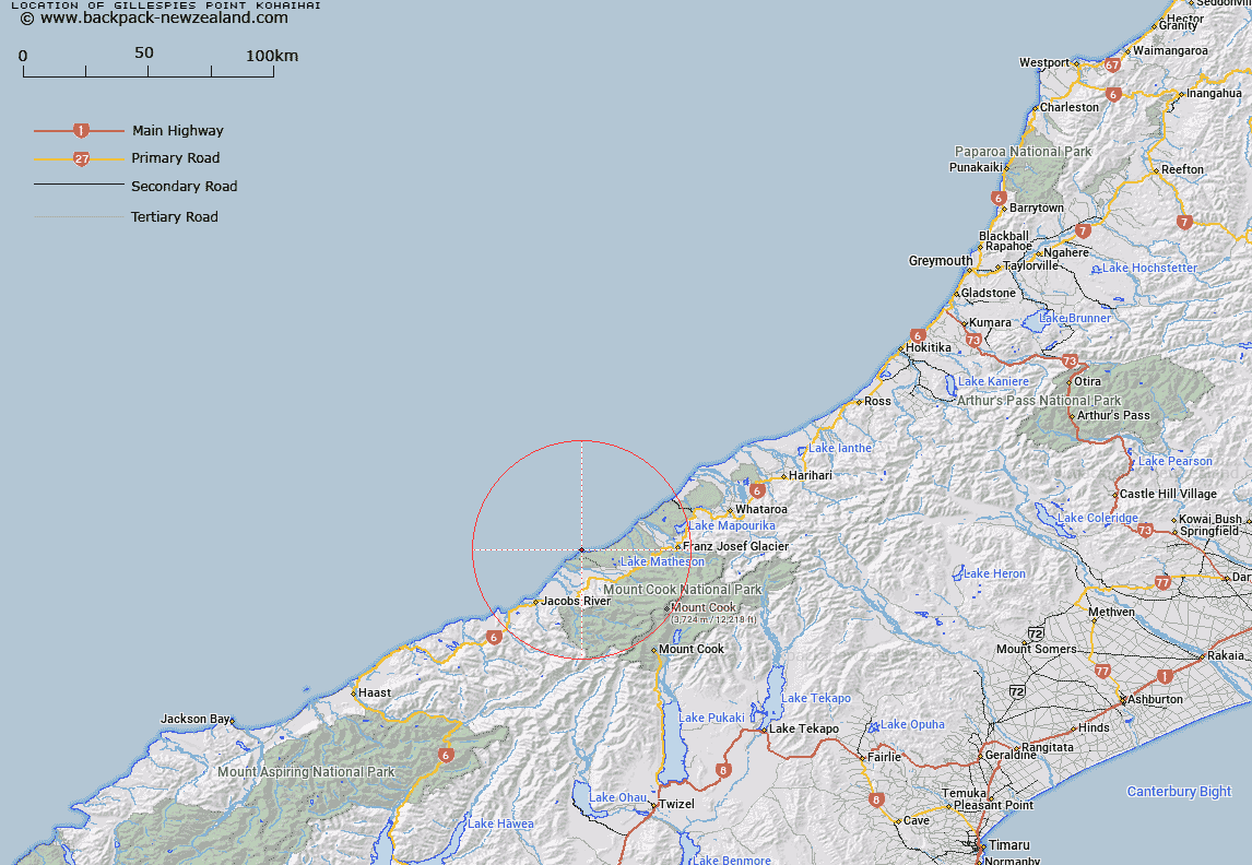
Map showing location of Gillespies Point/Kōhaihai


LINZ description: Feature shown on: NZMS260-H35 542520; NZTopo50-BW14ptBX14 442903;
Latitude: -43.396556
Longitude: 169.841374
Northing: 5190300
Easting: 1344200
Land District: Westland
Feat Type: Point


Scroll down to see a more detailed road map and below that a topographical map showing the location of Gillespies Point/Kōhaihai. The road map has been supplied by openstreetmap and the topographical map of Gillespies Point/Kōhaihai has been supplied by Land Information New Zealand (LINZ).

Yes you can use the top static map for you school/university project or personal website with a link back. Contact me for any commercial use.

Gillespies Point/Kōhaihai Map New Zealand


New Zealand places in our database
[ A ] [ B ] [ C ] [ D ] [ E ] [ F ] [ G ] [ H ] [ I ] [ J ] [ K ] [ L ] [ M ] [ N ] [ O ] [ P ] [ Q ] [ R ] [ S ] [ T ] [ U ] [ V ] [ W ] [ X ] [ Y ] [ Z ]


Closest 20 Points to Gillespies Point/Kōhaihai

Galway Point ( 4.32km )   Otorokua Point ( 4.69km )   Makawhio Point ( 23.44km )   Heretaniwha Point ( 31.43km )   Rehder Head ( 33.18km )   Canoe Point ( 35.38km )   Burrough Head ( 37.61km )   Buttress Point ( 38.08km )   Point Niccolo ( 38.37km )   Kea Point ( 38.93km )   Stoney Point ( 40.29km )   Commissioner Point ( 40.89km )   Tititira Head ( 41.86km )   Awataikato Point ( 45.75km )   Abut Head ( 46.83km )   Piakatu Point ( 47.25km )   Tasman Point ( 48.8km )   Beachy Point ( 50.76km )   Black Point ( 51.09km )   Woodcutters Point ( 53.18km )   Snapper Point ( 54.73km )   Blue Point ( 55.11km )   Bloody Point ( 55.13km )   Micks Point ( 55.76km )   Otumotu Point ( 56.88km )   Knights Point ( 60.89km )   Wanganui Heads ( 61.07km )   Arnott Point ( 62.3km )   Seal Point ( 64.21km )   Tauperikaka Point ( 68.59km )   Mussel Point ( 97.01km )   Totara Point ( 99.59km )   Blacksmith Point ( 107.47km )   Hobart Point ( 109.44km )   Picnic Point ( 110.86km )   Blowing Point ( 113.22km )   Jackson Head ( 116.53km )   Windy Point ( 118.01km )   Smoothwater Point ( 118.67km )   Burmeister Point ( 120.23km )