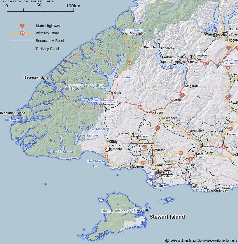
Map showing location of Eyles Lake


LINZ description: Between McKenzie and Chester Burns about four miles north of the South Fiord of Lake Te Anau. Esk Survey District.
Latitude: -45.249976
Longitude: 167.469058
Northing: 4974379.3
Easting: 1165982.6
Land District: Southland
Feat Type: Lake


Scroll down to see a more detailed road map and below that a topographical map showing the location of Eyles Lake. The road map has been supplied by openstreetmap and the topographical map of Eyles Lake has been supplied by Land Information New Zealand (LINZ).

Yes you can use the top static map for you school/university project or personal website with a link back. Contact me for any commercial use.

Eyles Lake Map New Zealand


New Zealand places in our database
[ A ] [ B ] [ C ] [ D ] [ E ] [ F ] [ G ] [ H ] [ I ] [ J ] [ K ] [ L ] [ M ] [ N ] [ O ] [ P ] [ Q ] [ R ] [ S ] [ T ] [ U ] [ V ] [ W ] [ X ] [ Y ] [ Z ]


Closest 20 Lakes to Eyles Lake

Lake Wisely ( 5.91km )   Lake Hilda ( 6.69km )   Lake Duncan ( 7.05km )   Lake Te Au ( 7.16km )   Lake Hall ( 9.11km )   Lake Cecil ( 9.59km )   Lake Ione ( 10.57km )   Lake Boomerang ( 10.7km )   Lake Eva ( 10.79km )   Lake Tuaraki ( 11.92km )   Bloxham Lake ( 12.49km )   Lake Minerva ( 12.65km )   Hidden Lake ( 12.78km )   Tawera Tarn ( 12.97km )   Lake Herries ( 14.56km )   Lake Freeman ( 14.88km )   Myth Tarn ( 15.85km )   Lake Mackinnon ( 15.87km )   Orbell Lake ( 16.43km )   Lake McIvor ( 17.11km )   Lake Norma ( 18.59km )   Lake Victoria ( 18.96km )   Lake Ogle ( 19.67km )   Lake Wapiti ( 20.41km )   Lake Annie ( 21.22km )   Lake Clark ( 21.42km )   Teardrop Lake ( 21.77km )   Lake Hankinson ( 22.56km )   Lake Marchant ( 23.03km )   Wade Lake ( 23.43km )   Lake Thomson ( 24.03km )   Lake Te Anau ( 24.05km )   Lake Richter ( 25.96km )   Lake Shirley ( 26.4km )   Lake Norwest ( 26.5km )   Shirley Lake ( 26.6km )   Deadwood Lagoon ( 26.8km )   Welcome Lake ( 27.3km )   Lake Te Aroha ( 27.39km )   Lake Katherine ( 27.94km )