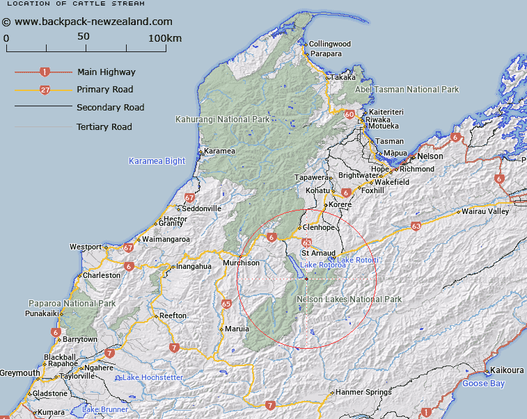
Map showing location of Cattle Stream


LINZ description: Left bank tributary of Sabine River rising 1.4km North-east of Mount Misery [Trig. P (Geodetic Code A5AQ)], flowing North-eastward, and joining Sabine River 1.7km upstream of Lake Rotoroa. Blocks XII and XV Rotoroa Survey District.
Latitude: -41.917857
Longitude: 172.688543
Northing: 5359297.1
Easting: 1574172.7
Land District: Nelson
Feat Type: Stream


Scroll down to see a more detailed road map and below that a topographical map showing the location of Cattle Stream. The road map has been supplied by openstreetmap and the topographical map of Cattle Stream has been supplied by Land Information New Zealand (LINZ).

Yes you can use the top static map for you school/university project or personal website with a link back. Contact me for any commercial use.

Cattle Stream Map New Zealand


New Zealand places in our database
[ A ] [ B ] [ C ] [ D ] [ E ] [ F ] [ G ] [ H ] [ I ] [ J ] [ K ] [ L ] [ M ] [ N ] [ O ] [ P ] [ Q ] [ R ] [ S ] [ T ] [ U ] [ V ] [ W ] [ X ] [ Y ] [ Z ]


Closest 20 Streams to Cattle Stream

Open Stream ( 1.99km )   Hopeless Creek ( 4.59km )   Sabine River ( 5.42km )   Cedric Stream ( 6.05km )   M?ori Stream ( 6.47km )   Bull Creek ( 7.14km )   Hukere Stream ( 7.56km )   Cupola Creek ( 7.89km )   Tier Stream ( 8.26km )   Ngaro Stream ( 8.75km )   Shift Creek ( 8.75km )   Summit Creek ( 9.61km )   Johansen Stream ( 9.66km )   Hodgson Stream ( 10.05km )   Swampy Creek ( 10.67km )   Atkinson Stream ( 10.87km )   Chandler Stream ( 11.1km )   Coldwater Stream ( 11.43km )   Boulder Stream ( 11.58km )   Clearwater Stream ( 11.61km )   East Branch Sabine River ( 11.73km )   Snows Stream ( 12.01km )   Travers River ( 12.14km )   Arnst Gully ( 12.34km )   Arnst River ( 12.34km )   D'Urville River ( 13.44km )   Gibbs Creek ( 13.62km )   Speargrass Creek ( 13.63km )   Te Horowai / Speargrass Creek ( 13.63km )   Whisky Creek ( 13.71km )   Mole Stream ( 13.97km )   Hamilton River ( 14.13km )   Tiraumea River ( 14.3km )   West Branch Sabine River ( 14.34km )   Three Peaks Stream ( 14.49km )   Pigeon Creek ( 14.65km )   Robert Stream ( 14.72km )   Tongue Spur Stream ( 14.99km )   McCaa Stream ( 15.47km )   Coleman Creek ( 15.64km )